-Dragonmount-Banner-Ads-1200x280.gif.ed90097d91aa5c65a5c17fab3b59c6f2.gif)
-Dragonmount-Banner-Ads-728x90.gif.a2f99d762ad611c51fbffc8b25a4efb4.gif)
-Dragonmount-Banner-Ads-320x100.gif.a233f9b759ce2a0c82ee7b9e890e85dd.gif)

Agitel
-
Posts
3070 -
Joined
Content Type
Profiles
Forums
Store
Gallery
Blogs
News
Downloads
Events
Posts posted by Agitel
-
-
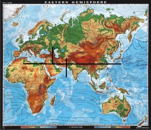
Randland is Earth. Aside from a number of references to 20th century people, and even a token Mercedes-Benz hood ornament in the Panarch's Palace in Tanchico, the geography bears too many resemblances for it to be more than coincidence. The continent Randland is on is about like this:
While our Age lies in both the past and the future of the Third Age, I believe that our current turning of this particular Age lies in the past. The names being similar and the Mercedes-Benz hood ornament cinch it. While the Ages are similar as they repeat themselves, they wouldn't be that exact.
And for a previous comment that I noticed, channeling isn't a Talent in every Age of the Wheel. The Ring of Tamyrlin that Lews Therin wore was considered to be an artifact of the first channeler.
-
That would make the widest part of Seanchan about 6,750 miles. That's pretty ridiculous. Are we sure it's 1,500 WOT leagues?
On the other hand, this might make lining up features much easier.
-
I do agree it is possible ROB_88, it just seems like the less likely scenario to me. To assume continental drift assumes some millions of years, which is possible with enough turnings, but I don't think we're so far gone off of the geography RJ may have been working with.
I'm considering trying to see if I can get Seanchan out of the Americas. What do we have to go on that the widest part of Seanchan is 3,500 miles (about) across, the same distance from coast to the Spine of the World in Randland? Is it just the world map?
-
There's no equator running through Randland. Tear ends up running somewhere along the same lat as Florida, while Ebou Dar and Illian run south of that. Apprently, snow does reach the northern reaches of Tear and Illian, at least somewhat.
nope, that doesn't seem right. remember that people of the south coast believe that the snow is a lie. therefore it can't snow anywhere near Tear or Illian and that must be much more south
Have you looked at the Jordan approved world map posted on the first page. The equator on my comparison map lines up near perfectly. Keep in mind that while Tear is at the same lat as Florida, it's also in the same position deep into Saudi Arabia, which I don't believe is well known for snow. Climate can be influenced by a lot more than latitude. Perhaps the Sea of Storms has a big warming effect, I can't say. but I don't think we can rule out this latitude. And as I said, at certain points, I believe it's in PoD, one of Rand's chapters makes a point that it doesn't snow "this far south in Illian" or something that effect, which sort of implies that it snows further north. Keep in mind people can't just hop in a car and travel, most probably haven't ever been far outside of the city or are very far from where they were born.
How about just believing what Robert Jordan said, that he lives in the Two Rivers. We know oceans rose and fell so maybe the Atlantic Ocean is no more. In the middle of the Atlantic around twenty three hundred miles away from South Carolina Tectonic plates meet and create a large ridge. Maybe thats the forerunner to the Spine of the World.
I always took that to be metaphorical. I just think that the idea that North America had 7000 miles added to it's eastern coast and 2700 miles blasted off its west coast, with an eastern and southeastern coast that lines up with certain geographical features and highlands in western Europe and Northern Africa and having the land to the east of Randland have features lined up with the Ural Mountains, Himalayas, and even match up extremely well with southeastern Asia to be far too much of a coincidence. That, and also considering that the length from the coast of Randland to the coast of Shara matching up near perfectly to the distance from my comparison endpoints between Europe and Asia to be far too coincidental to dismissed so lightly.
-
A quick note, RJ has confirmed that one isn't born ta'veren. The Wheel makes you one when it needs you.
-
If Lan has been lucky, I'd say it's more than Wheel's doing than him truly being ta'veren. Or perhaps it isn't magical luck at all, but he's just had some very good coincidences happen.
-
The equator running through Shara seems to line up really well. There's no equator running through Randland. Tear ends up running somewhere along the same lat as Florida, while Ebou Dar and Illian run south of that. Apprently, snow does reach the northern reaches of Tear and Illian, at least somewhat.
Anyway, if Seanchan is as wide as that, I may be able to come up with something better. Not now, though, but I'm pretty sure I can match up the Appalachians a bit.
-
Seeing the WoT map superimposed on our world map seems to imply that the Male AS did quite a number on the world indeed. I mean half of North America, most of Africa and all of Greenland are just missing. I suppose some of it could be to to natural shifting of tectonic plates or natural disasters before the AOL but geez. It looks as though they literally tore NA to shreds.
Yes, but I can't verify if the continents are to scale. Mostly, I cropped the contienents out of the Randlandian map, and then pasted them onto our world map, with scale approximate to the general consensus that Randland+Shara = Eurasia, LotM = Austrailia, and Seanchan = the Americas. I'd like to check the Big White Book to see if it's mentioned there, but I don't have a copy.
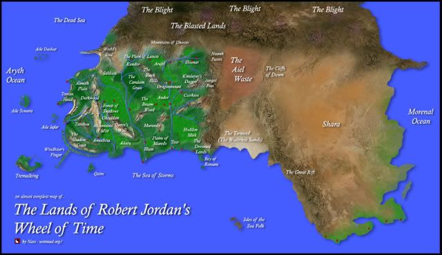
According to the Roleplaying Game, the Glossary, and RJ himself, Randland (that is the Dragonwall to the Aryth Ocean) is anywhere between 3,000 to 4,000 (our) miles. This is approximately the size of the US, where varies from <3,000 to ~3,400 miles at it's widest point. Now, Europe is considered to be the Ural Mountains in Russia and then Eastward to the Atlantic Ocean, and I got ~3,100 miles for that. So, both NA and Europe work for Randland. The plot thickens....
But Randland isn't the entire continent. If you count the Aiel Waste and Shara, the distances match up the Europe and Asia.
As for the maps we've been given, particularly the fan maps, I consider them to be Jordan approved (as they are), but I don't consider them to be 100% accurate. Keep in mind also that it's difficult to superimpose a sphere onto a flat map. Most real maps of the world are distorted vertically. Randland (nor any of the maps) have lat/long lines, so lining things up exactly by overlapping isn't going to work very easily.
As for Seanchan's placement, I agree with the first map more. In my view, most of North America got destroyed (the western coast is just gone), and what was the east is now in the west. The bulk of the southern continent would sit with the top half of South America, and that curved mountain range to the southeast matches up with the curve of the Andes. I'm FAR less sure about Seanchan than I am about the eastern continent, which I am very confident in. Let me attempt something.
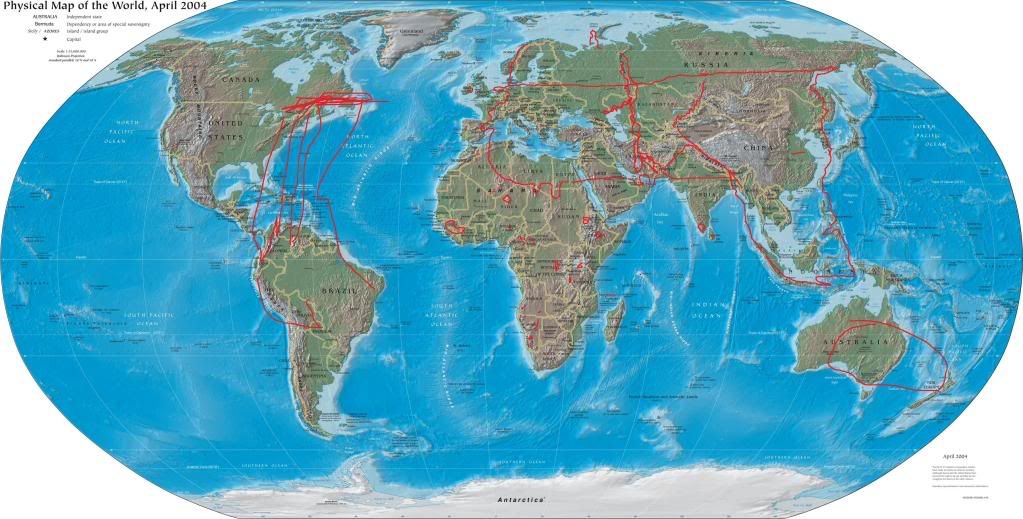
To be honest, I gave up on drawing Seanchan. My scale was off tremendously. However, I think the drawing shows that it's more eastern position still puts it far enough away from Randland for quite a long voyage, if a little shorter than the one Columbus took.
-
but remember that the Breaking changes everything. the landmasses don't have to be similar to what they are today.
for all we know, Randland could be where the pacific ocean is now
In my view, there are far too many similarities, and you may be assuming too much about the breaking. If my theory is correct, a TON has changed about the world, but there's still some parts recognizable. The shape of Shara, the mountains bordering Termool, what we heard about the distance of Comelle from where the border of the sea once stood, Asmodean's birthplace (being on the Caspian Sea (or maybe Aral) just seem to fit well, as well as the eastern coast of Randland running along the higher altitudes of western Europe VERY well. As for elephants being on Seanchan, I'm pretty sure there's also mention of them being in Shara, too, or at least similar creatures. Keep in mind that this is after the AoL (or even just a technologically advanced non-channeling civilization), these creatures and people could have shifted about easily during that time.
I also believe that Africa did not drift into NA. Tremalking fits in well with the continent if you look at a map, as does the border of the Shadow Coast along with some high lands in that region of northern Africa at the right latitude. What remains of Africa is now the Sea Folk Isles. I believe they're missing from the world map.
And I can't believe that 6000 miles of extra land was added to North America during the Breaking when there's so much evidence that the other theory is more likely. I mean, I could be wrong, but I prefer the most parsimonious answer that fits the evidence better..
-
Shayol Ghul is described as having once been on an "idyllic island in a cool sea". I believe the thought of it being a tropical resort may be a misconception, one I once believed. It may have been a resort, but I don't believe it was tropical, particularly if it was in a cool sea. Also, keep in mind that the weather was regulated with the power in the AoL.
-
Glad to see people liked this.
That small? The area it covers is pretty huge, 3,500 miles across and 2,200 miles from the Blight to the coast! As for the temperatures, I thought so, too. However, now that I've done more measurements on the globe I'm convinced it goes more south. Keep in mind that the northern coast of Germany and such is at about the same latitude as the north-south halfway point between British Colombia/Alberta/Saskatchewan/Manitoba/Quebec. I live far to the south of that, in New Hampshire, USA, and we get snow on the ground well into April and even May sometimes. This about fits with the conditions that Faile gives us as to winter in Ghealdan being like early spring in Saldea. Western and even northern Europe is warmed a lot by the Gulf Stream coming up from the Caribbean, and I doubt by this Age that the Gulf Stream exists anymore. The Mediterranean also has a huge warming effect on southern Europe. As for how far south it goes, where the Himalayas meet the Ocean we're on par with the southern tip of Florida. Considering the concept of snow can't even be believed to people in Illian and Tear, I don't think it's unsafe to say that they're as far south as that. This may be a mistake in judgment on my part, but considering the changes since the Breaking it may be better to think of the climate being more representative of the latitude in comparison to North America, not to Europe. We also don't know whether the planet's warmed or cooled, so if it's warmed then we can shift everything further north. Let's just take a quick look so we can get a clear view of the latitude.
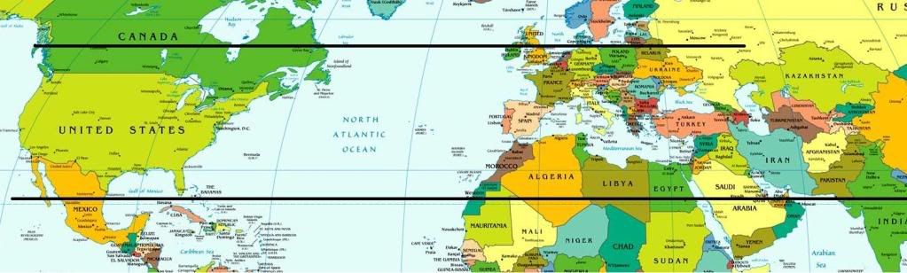
With that said, I've also drawn a new picture. The overlap wasn't working for me, so I decided to craft my own outline. As I was drawing, I was surprised by how much I could follow the mountainous regions, particularly along the west. If the outline makes that difficult to see, compare it to the unmarked map above and you should be able to follow where I traced.
Shara ended up looking a little different, too, but I think the resemblance is close enough, and I can't expect an exact match. And as all maps are distorted, north and south get stretched, too. The distance from North to South is 2,200 miles, as I measured, and I believe it's 3,500 miles from west to east along the more southern portions.
And I think I placed Shayol Ghul... maybe... If that is true, and if Asmodean was born on some future version of the Caspian or Aral Sea... then I think we have hints that the world didn't change too much between the First and Second Age. ANYWAY. Enough talk, here's my outline.
I don't mean to be so authoritative, I just had a brainstorm over the past couple of days, and with this new theory of the land in place, I submit myself to your will.
-
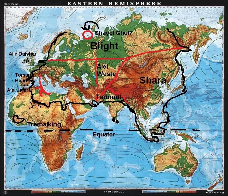
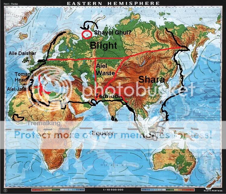
Has this been discussed before? What I'm saying is, has anybody matched the world of the books to our own? It is our world, after all, if only somewhat broken (at least once). Anyway, here's a map of the continent that the Westlands, the Blight, the Aiel Waste, the Waterless Sands, and Shara share. I'll continue with this, though I'd be surprised if it hasn't been discussed yet.
The generally accepted distance from the Spine of the World to the Aryth Ocean is 3,500 miles. If we extrapolate that eastwards on the map, the Morenal Ocean is probably about 5,000 - 6,000 miles east of the Spine of the World. As this world is our world, just in some fantastic future, and if we try to match which hemisphere of the world to look at, we can easily dismiss the Americas, as they don't stretch 8,500 miles from west to east. Let's look then to the eastern hemisphere.

Looking for similar features (for I can't believe that the world doesn't change 100% in the span of a single age or two) to find a starting point to make comparisons (you may want to find a better map to follow for this), I notice something peculiar about the mountains bordering the Termool and the Himalayas. Do you see it? That triangular arch? Those mountains are the same. The difference is that the southern half of India fell off the face of the map sometime between 2009 AD and 1000 NE. This is also at about the right latitude for Illian, Tear and Altara if the weather means anything. Let's draw some lines on this map of our eastern hemisphere. 3,500 west and 5,000 miles east of the eastern part of the Himalayas where the Spine of the World meets (I think you'll enjoy this). I'm also going to draw a line 1,600 miles to the north of there, as New Spring hinted that was the straight line distance north Tar Valon was of the Sea of Storms. There's no scale on the map, but I've whipped out my globe and done the measurements, you can verify this yourself if you don't believe me.
This fits roughly with what we learn of how much further it used to be to the World Sea in the Age of Legends, given as 100 leagues [The Shadow Rising : The Road to the Spear]. The city of Comelle was said to have "clung to the mountains overlooking the sea". We can't say that the geography was precisely the same, we don't know how much the geography changed between the First and Second Age, but this could be to Spain/Portugal or it could be a reference to the Atlas Mountains in north western Africa. The Spine of the World lines up pretty well with the Ural Mountains, though in the Third Age they certainly lead further south and are far higher, particularly at around the Jangai Pass, which would lie just to the east of the northern reaches of the Caspian Sea, which, if it existed in the Age of Legends in some form, may be the body of water that the port town of Shorelle, where Asmodean was born [The Fires of Heaven : The Gift of a Blade]. Or perhaps the Aral Sea. The world could have been different, but it is interesting how these things match.
I could begin to explain the eastern part of the continent, but I'll let this next picture speak for itself. Let's overlap. I've painstakingly tried to match this up to the correct scale, but keep in mind these hand-drawn maps aren't perfect, either, but enough excuses. Here.
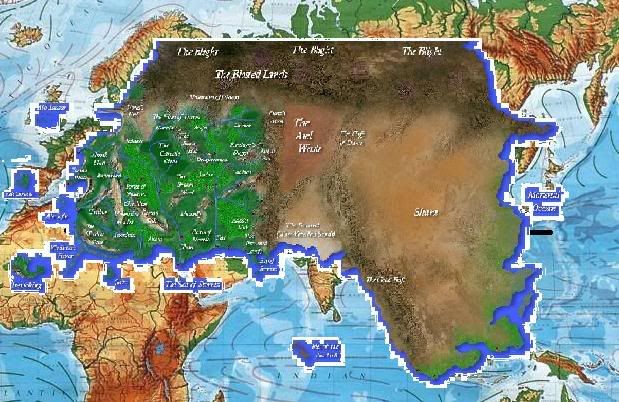
I was actually sizing it to be a little bigger when I noticed that Aile Daishar hits England/Ireland pretty well and Aile Somara hits Spain/Portugal area. More than likely the Isles of the Sea Folk are supposed to be Southern India or something. Much of southeastern Shara is actually southeast Asia with the landmass between the islands filled in. The eastern coast of the Blight hits the northern coast of Europe across from Scandinavia.
I just found this very interesting, and I hope others will, too. Even if this has been discussed before, I'm sure it will be new to some.
Coming from this, Seanchan is what became of the Americas and, though I can't find the map, The Land of Madness or whatever it's called is, of course, Australia. Can't say the name isn't applicable already.
Is Randland on Earth?
in Wheel of Time Books
Posted
Well, yes, but the most parsimonious answer is just that it is Earth. Jordan obviously intended it to be Earth. He referenced Mother Theresa, Queen Elizabeth, Mercedes-Benz, John Glenn, Sally Ride, Anne Landers, Gautama Buddha, and America and Moscow. Of course you're probably going off the whole 'every possible choice creates a split-universe scenario', but that's just an exercise in futility. The planet itself is still Earth, obviously.
And yes, Seanchan would be what happened to the Americas. My guess is that the Land of Madmen is related to Australia and New Zealand. As for the Ogier, they seem to have the means of crossing world's themselves, they don't have to wait for worlds to touch (which hasn't been hinted at as a possibility within it). I just noticed that you were being funny in your post, but I'll leave the rest anyway.