


Zidel333
-
Posts
92 -
Joined
-
Last visited
Never
Content Type
Profiles
Forums
Store
Gallery
Blogs
News
Downloads
Events
Posts posted by Zidel333
-
-
the person above me forgets jackass.
-
The person above me assumes too little.
-
banned for not sharing drink. *drinks*
-
the person above me expects too much of me.
-
the person above me loves puppies...I hope.
-
the person above me has no taste in screenames -- don't be hatin' cuz i'm only half evil.
-
the person above me loves cakewreaks.blogspot.com.
-
the person above me underestimates my time wasting skillz on the internets. So, I humbly submit this parody in return.
-
The person above me does not recognize Carrot Top, which makes an insane Dragon Reborn parody if I do say so myself.
-
The person above me has no taste in wickedly awesome cool nicknames!!! :P
-
The person above me needs a hug. *hugs*
-
Banned for not using Ban Deodorant. Roll on FTW!!
-
The person above me just lost The Game.
-
The person above me's number of posts is both amazing and scary. Over 9,000!!
-
the person above me is awesome for having a sense of humor... (but wait, are you saying I scare you?!?!)
-
The person above me does not have Foretelling.
-
Banned for agreeing with me.
-
Banned cos I don't recognize you. Heh. See what I did there?
-
Banned for keeping tabs on time. This is the internets. Time has no meaning.
-
6,750 miles seems way too big... just by looking at the map, it should be 4500-5000 miles, at most.
-
I do agree it is possible ROB_88, it just seems like the less likely scenario to me. To assume continental drift assumes some millions of years, which is possible with enough turnings, but I don't think we're so far gone off of the geography RJ may have been working with.
I'm considering trying to see if I can get Seanchan out of the Americas. What do we have to go on that the widest part of Seanchan is 3,500 miles (about) across, the same distance from coast to the Spine of the World in Randland? Is it just the world map?
Well we do have this form "Robert Jordan's World of The Wheel of Time"
Far across the Aryth Ocean lies the continent of the Seanchan. Bordered by the Morenal Ocean to the west and the Aryth to the east it is known to be approximately fifteen hundred leagues wide at its greatest breadth in the southern hemisphere.So does anyone know how to convert leagues to miles? If so then we'll have our answer.
I guess no one read my previous post, so I'll just quote it again:
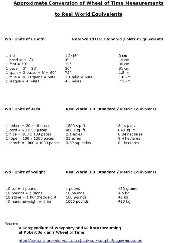
What's most striking is that Randland world appears to be missing a great deal of land mass compared to our world. If someone has access to the White Book, can you add up roughly how many miles are the continents, convert them to our miles (http://personal.ars-informatica.ca/paul/wot/wot.php?page=measures) and then compare them to our total square mileage for land mass? The answer would be surprising methinks.
There does exist a conversion table for WoT measures to our real world measuresments. I had linked it above, but obviously no one checked it out. I assume that the conversion is approximate, but it's better then wild guessing.
Cause I'm awesome, here are the tables, and a direct link in case you have issue reading it:
http://i746.photobucket.com/albums/xx103/Zidel333/wotmeasures2.jpg
-
::)
and what lesson is there with the cuendillared harbors
LMAFO. You tell me. :P
-
Seeing the WoT map superimposed on our world map seems to imply that the Male AS did quite a number on the world indeed. I mean half of North America, most of Africa and all of Greenland are just missing. I suppose some of it could be to to natural shifting of tectonic plates or natural disasters before the AOL but geez. It looks as though they literally tore NA to shreds.
Yes, but I can't verify if the continents are to scale. Mostly, I cropped the contienents out of the Randlandian map, and then pasted them onto our world map, with scale approximate to the general consensus that Randland+Shara = Eurasia, LotM = Austrailia, and Seanchan = the Americas. I'd like to check the Big White Book to see if it's mentioned there, but I don't have a copy.
According to the Roleplaying Game, the Glossary, and RJ himself, Randland (that is the Dragonwall to the Aryth Ocean) is anywhere between 3,000 to 4,000 (our) miles. This is approximately the size of the US, where varies from <3,000 to ~3,400 miles at it's widest point. Now, Europe is considered to be the Ural Mountains in Russia and then Eastward to the Atlantic Ocean, and I got ~3,100 miles for that. So, both NA and Europe work for Randland. The plot thickens....
But Randland isn't the entire continent. If you count the Aiel Waste and Shara, the distances match up the Europe and Asia.
As for the maps we've been given, particularly the fan maps, I consider them to be Jordan approved (as they are), but I don't consider them to be 100% accurate. Keep in mind also that it's difficult to superimpose a sphere onto a flat map. Most real maps of the world are distorted vertically. Randland (nor any of the maps) have lat/long lines, so lining things up exactly by overlapping isn't going to work very easily.
As for Seanchan's placement, I agree with the first map more. In my view, most of North America got destroyed (the western coast is just gone), and what was the east is now in the west. The bulk of the southern continent would sit with the top half of South America, and that curved mountain range to the southeast matches up with the curve of the Andes. I'm FAR less sure about Seanchan than I am about the eastern continent, which I am very confident in. Let me attempt something.
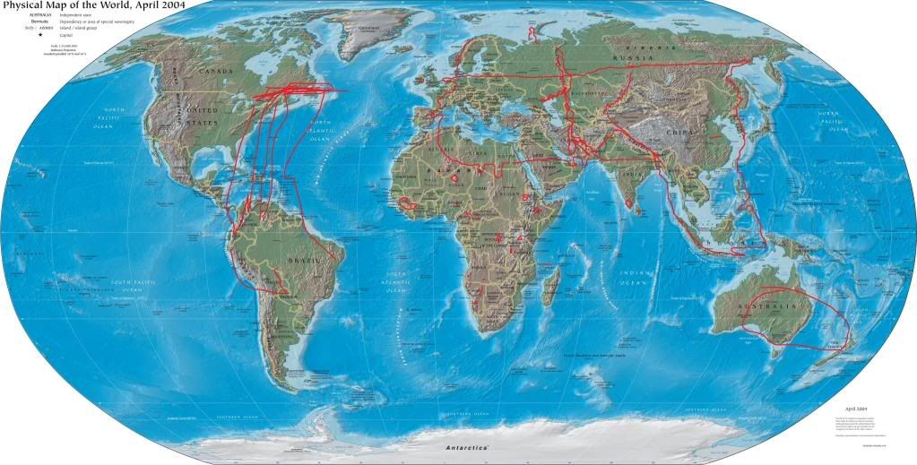
To be honest, I gave up on drawing Seanchan. My scale was off tremendously. However, I think the drawing shows that it's more eastern position still puts it far enough away from Randland for quite a long voyage, if a little shorter than the one Columbus took.
LMAO -- yeah, manipulating the maps is pretty hard. As it is, the map is pretty good.
The scale is very much off -- the width of Seanchan is approximately the width of Randland + Aielwaste. It's pretty big. Either they dredged the oceans, or the bulk of South American smashed into North America. Also, LoM is more then 2x the size of Australia, as far as I can tell.
Btw, the equator line that runs through Seanchan and Randland is obviously off. Unless the male Aes Sedai managed to knock the earth off it's tilt?! Never though of that before. If so, that might explan some of the discrepancies in weather and the climate zones of Randland. (Does Tear and Illian EVER get snow?!) Anyone want to do the research and make a climate zone map of Randland? Haha, I kid, but that would be crazy.
-
I am sorry Zidel, I was eating an apple, and had use of only one hand to type.
I was just saying why the Seanchan didn't leave.
I was agreeing with you pretty much, on the realization of why they didn't leave.
It's cool. :)
The person above me game! >Xtra Newbiefriendly!
in Community Games
Posted
the person above me is an octopus/squid.